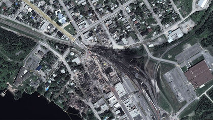
It’s been almost a year since the July 6 train derailment in Lac-Megantic, Que., but the reminders for the people who live there are near-constant. As the cleanup of the disaster enters its second phase, some of Lac-Megantic’s residents have discovered yet another reminder: An aerial view of the scorched earth in their town where the disaster occurred, displayed on Google Maps.
“It’s disgusting and it makes no sense,” said Emilie Bedard, a co-ordinator at Lac-Megantic’s tourism bureau.
Typing in “Lac-Megantic” into Google Maps shows an apocalyptic image with the centre of town resembling a black hole, rail cars burned to a crisp and strewn like matchsticks, and Lac-Megantic’s downtown buildings completely destroyed.
“The scene only looked like this for the two weeks following the accident,” said Ghislain Bolduc, the provincial MNA for the Megantic riding.
Bolduc told QMI Agency that the photo reeks of “sensationalism.”
“Is there a way to get to get Google to change it?” wondered Audrey Roussin, an agent in the Lac-Megantic tourism office.
“Yes, we had a horrible tragedy occur here, but we’re trying to build something positive.”
QMI Agency repeatedly tried to contact Google over the last several days, but have not had a response.
Agencies/Canadajournal
 Canada Journal – News of the World Articles and videos to bring you the biggest Canadian news stories from across the country every day


