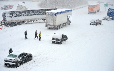
The Northeast braced Friday for a fierce winter storm that threatened to dump a foot of snow on some places and coat New York and Boston over the weekend with their biggest accumulations of the season.
Lake-effect snow whipped Buffalo and Rochester, N.Y., and Erie, Pa., on Friday morning, and 5 to 8 inches of snow was expected to fall on parts of Illinois, Indiana and Ohio from Friday evening into Saturday. Indianapolis was expected to get as much as 5 inches.
Freezing rain and sleet were expected to cause problems Friday in Kansas, Arkansas, Missouri and Illinois, slickening bridges and overpasses.
The National Weather Service called the whole thing a “complex storm system” stretching from Missouri to the northern tip of New York.
Boston Snow
The bulk of the storm was expected to miss Washington and Baltimore, said Tom Kines, a meteorologist with AccuWeather Inc. in State College, Pennsylvania. An area from central Pennsylvania through upstate New York and into New England will get the heaviest snow, Kines said.
“The farther north you go, the better the snow is going to be,” Kines said by telephone.
“It will be great for the ski areas. It should be a dry and powdery snow.”
Boston will probably get 4cm to 8cm of snow, said Dan Pydynowski, a meteorologist with AccuWeather. Accumulations in the city will be held down because the precipitation may change over to rain or a mix of freezing rain and sleet early tomorrow.
Areas north and west of Boston may get 14cm, according to the weather service. A coastal flood advisory has been issued for the east coast of Massachusetts including Cape Cod. Waves may rise to 10 feet with a 2-foot storm surge washing over roads and flooding basements, according to the weather service.
The heaviest snow will fall in Boston starting this evening, Pydynowski said.
Farther west, Cleveland and western New York may get 5cm as the snowstorm passes through, according to the weather service. Chicago may get as many as 6cm of snow before precipitation stops this afternoon.
 Canada Journal – News of the World Articles and videos to bring you the biggest Canadian news stories from across the country every day


